
Highway 36 Construction Update – Summer 2014
What is the current status of US 36 between Lyons and Estes Park?
Following the temporary repairs made by the National Guard to temporarily reopen US 36, the roadway was still at risk of losing existing embankment and roadway.
US 36 was identified as the first mountain corridor to begin and complete permanent repairs following the September 2013 floods. As a critical route between Estes Park and the Front Range for residents and tourists, this corridor’s repairs were targeted for several reasons:
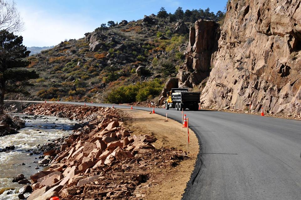
The alignment along US 36 provides the opportunity to keep the roadway away from the river more frequently than other mountain highways.
- A partnership between the Colorado Department of Transportation (CDOT) and Central Federal Lands (CFL) combined expertise to work on this corridor.
- US 36 will serve as a primary detour route during permanent repairs to SH 7 and US 34. Starting with the US 36 corridor, CDOT is staggering the work being performed on mountain corridors impacted by the flooding, thereby lessening impacts to the communities and always maintaining access to the town of Estes Park.
What will be done for US 36 repairs?
Recognizing the unique nature of this corridor, CFL and CDOT combined their expertise and resources to design and construct final repairs. The intent has been to stabilize areas that failed during flooding and to “armor” banks of the river channel, reducing possibility of future river impacts to the highway.
This approach has included shifting the roadway away from the river channel 5 to 50 feet (an average of 20 feet) by removing portion of existing mountainside (approximately 250,000 cubic yards). A portion of rock generated from blasting portions of the mountain was used to stabilize and protect the slopes near the river to reduce effects of future runoff and flooding. Leftover materials have been donated to local agencies, towns, and counties to help with their repair efforts.
Once complete, the improved stretches of roadway will be 12-foot lanes with 6-foot shoulders. Pre-flood, there were 12-foot lanes with minimal shoulders. Not only will the additional shoulders help widen the highway, but the shoulders will also help improve safety by providing space for emergency pull-offs and making it safer for bicyclists. Furthermore, by softening some of the mountain curves, sight distance will be improved along several of the more severe curves on US 36, including Dead Man’s Curve and the approach to Longmont Dam Road.
What happened during Phase I of the project?
Phase 1 (January 2014 through June 2014) was focused on activities needed to be completed before the major spring runoff, specifically blasting into the mountainside to realign the road away from the river. This phase involved extended road closures and an approximate 20-minute optional SH 7 detour that required patience from residents, businesses and tourists.
What will happen during Phase 2 of the construction?
Phase 2 (July 2014 through late Fall 2014) will have significantly less impacts to residents, businesses and tourists. The work will involve crews constructing the remaining necessary embankment, road base, asphalt, signing/striping and safety features to repair the highway on a long-term basis. Due to the increase of vehicles traveling on US 36 during the summer, traffic will be maintained during the day, and no weekend daytime construction will occur. Delays of up to 15 minutes during the day can be expected due to necessary lane reductions. Additionally, there may be occasional longer delays overnight.
The anticipated contractor for the project, Kirkland Construction, will need to close the entire road between milemarkers 18 and 19 for eight consecutive days at some point during the construction. Residents will be given notice at least two weeks in advance of the closure. Apple Valley Road will be used as the detour for credentialed local residents and businesses only. Residents that live along US 36 from MP 10.7 to MP 20, including residents in Big Elk Meadows, Pinewood Springs, Longmont Dam Road and Apple Valley, will be credentialed. Boulder County Sheriff Department will be manning the detour to ensure only credentialed residents and deliveries are allowed. Other traffic will need to go on SH 7 or US 34 during this closure.
How will information be communicated?
CDOT will coordinate closely with local representatives to share construction updates. In addition to public meetings to discuss upcoming work, CDOT will maintain a project hotline and website that will include weekly schedules so that the public can plan accordingly.
Project Hotline: 970-591-0001
Project Email: US36FloodRepairs@PublicInfoTeam.com
Project Website: http://www.coloradodot.info/projects/floodrelatedprojects/us-36-lyons-to-estes
General Flood Repairs Website: www.coloradodot.info/projects/floodrelatedprojects
Recent Comments